Intro to Taïwan
Subdivisions
Taïwan is divided in 16 counties and 6 special municipalities. They're often named after the capital of the county, followed by the title "county" or "city".
16 counties
- Changhua county 彰化縣
- Chiayi City 嘉義市
- Chiayi county 嘉義縣
- Hsinchu City 新竹市
- Hsinchu county 新竹縣
- Hualien county 花蓮縣
- Keelung City 基隆市
- Kinmen county 金門縣
- Lienchiang county 連江縣
- Miaoli county 苗栗縣
- Nantou county 南投縣
- Penghu county 澎湖縣
- Pingtung county 屏東縣
- Taitung county 臺東縣
- Yilan county 宜蘭縣
- Yunlin county 雲林縣
##6 special municipalities
- New Taipei City 新北市
- Taipei City 臺北市
- Taoyuan City 桃園市
- Taichung City 臺中市
- Tainan City 臺南市
- Kaohsiung City 高雄市
To learn the cities and counties you can use the Seterra quiz and the City quiz.
Geography
Taïwan has a main island and quite a few secondary islands, some of which are quite near continental China.
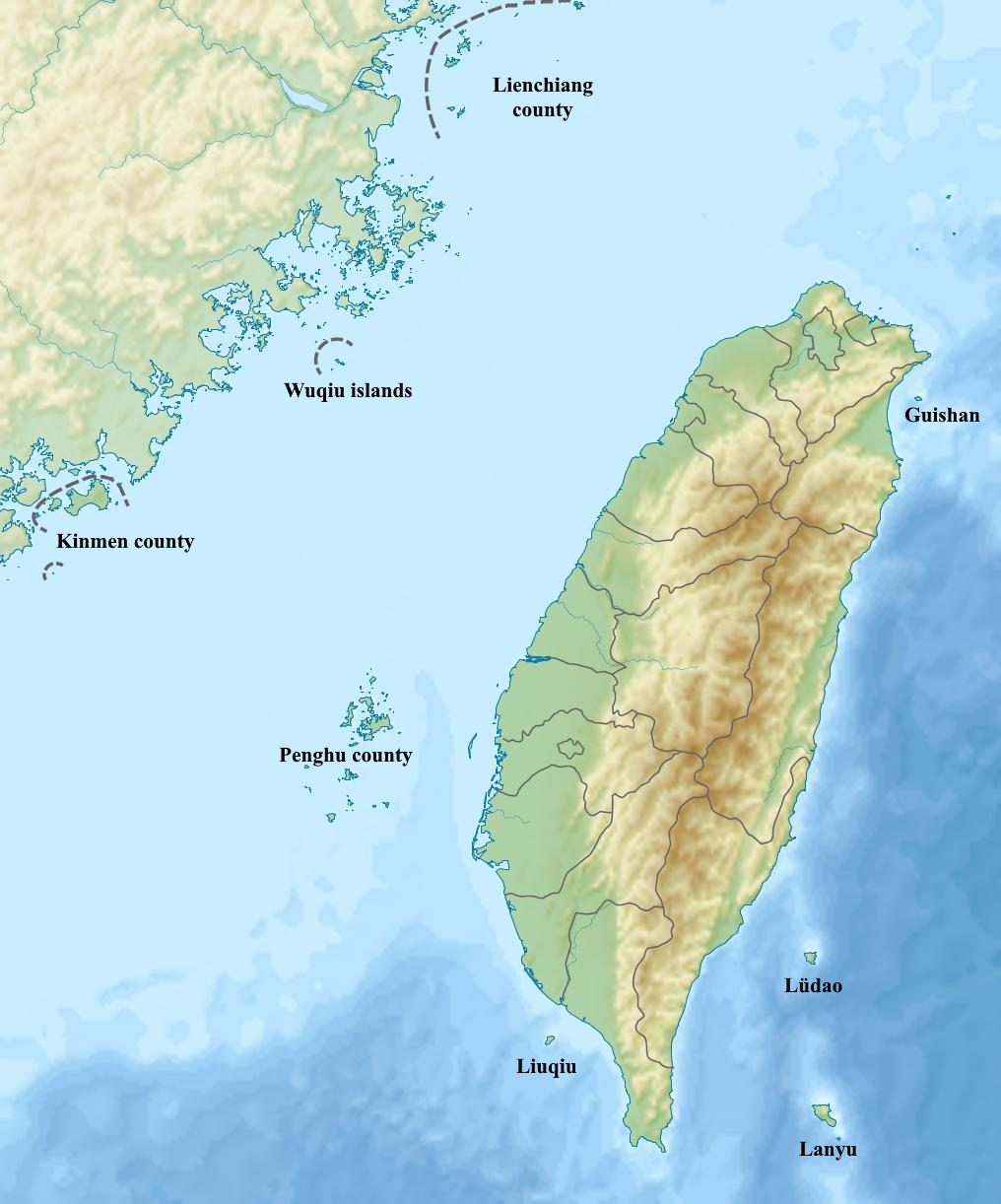
The Chungyang mountain range (Zhongyang shanmo in chinese) covers the center and eastern part of the main island. All the islands have streetview coverage except the small Wuqiu islands.
Roads, Markings, and Signage
road types
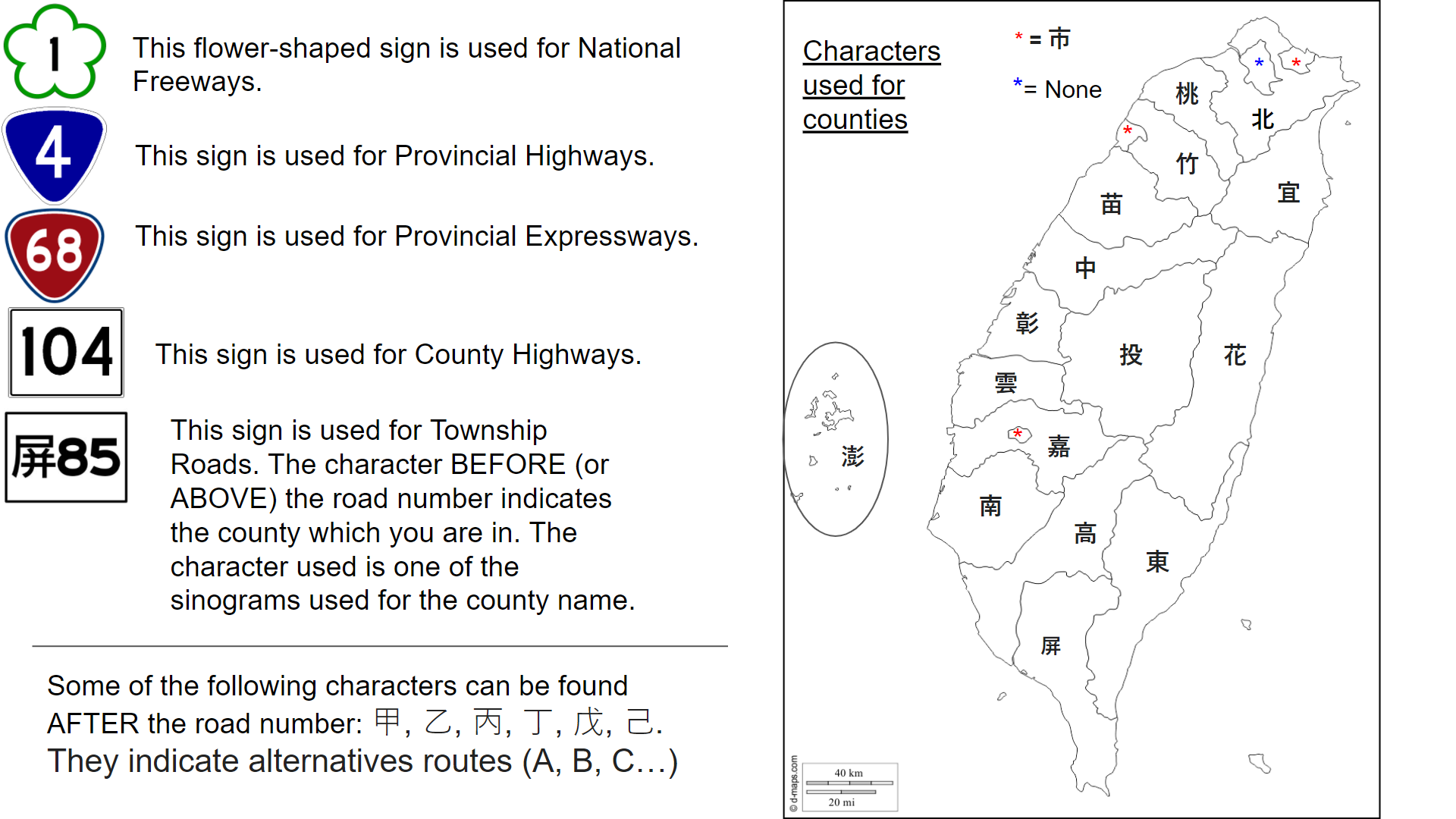
There are 4 types of roads in Taïwan :
- National freeways : 1
- Regional highways :1 or 60
- County roads : white square.
- Township roads : they have a county symbol in front of their number.
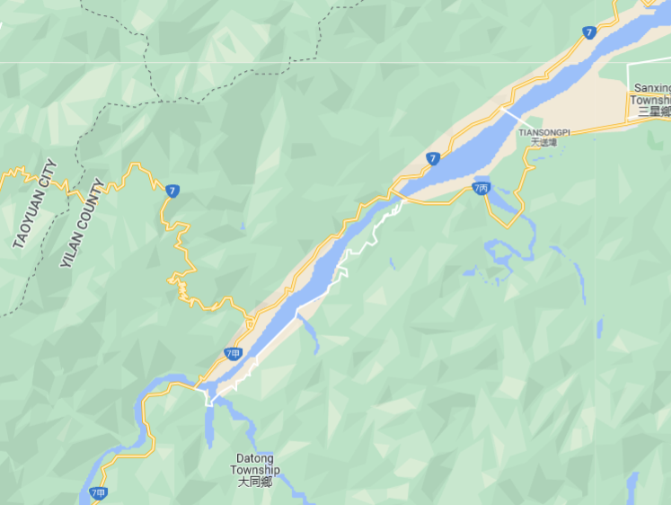
 A road can be split in different sections, identified by a symbol after the number. For example road 7甲 has several branches like 7丙 and , which is the equivalent of road 7A and road 7C.
National freeways
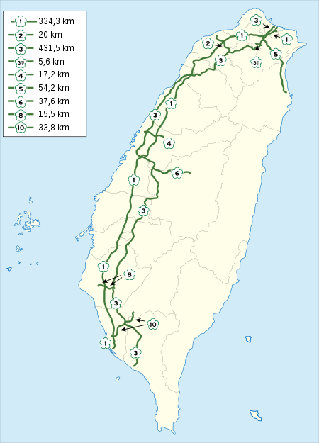
National freeways are numbered 1 to 10. Every 100m, there s a kilometer sign telling you the distance with the north end of the road for north-south roads, or the west end of the road for east-west roads. Exit numbers also match this same distance.
Regional highways
On the map, the triangle logo appears in blue, unless the number is 60+ in which case they appear in red. Beware, the color on the map doesnt necessarily match the color in the streetview.
Some noteworthy regional highways :
- 1 and 3 follow the west coast.
- 2 follows the north coast. -9 and 11 follow the east coast. There is no global order but here are a few tricks : 2/4/6... until 26 go from north to south, 60's roads are rather north, 70's rather center, and 80's rather south.
County roads
They range from 101 in the north to 200 in the south of the main island. Roads 201 to 205 are in Penghu county.
Township roads
Township roads have a symbol in front of their number, it looks like this : 市12. You can learn the symbols with the township roads quiz Taïwan, but you can also find them by scanning the map. Indeed, the road symbol is one of the first 2 symbols of the county name :
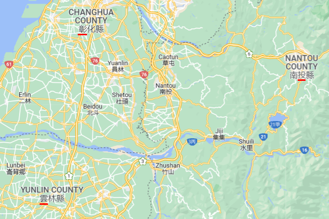
Exception : Keelung city, Hsinchu city et Chiaoyi city all use the 市 symbol which simply means "city".
Phone codes
In Taïwan, area codes range from 02 in the north to 08 in the south. 09 is for cell phone numbers.
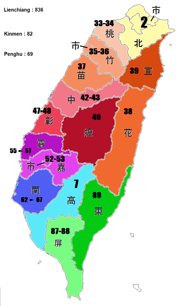
You can learn them with the area codes quiz.
Electric poles
Recognize taïwanese electric poles
The main characteristic of taïwanese electric poles are the black and yellow diagonal stripes at the bottom. The stripes are :
- similar to the japanese ones, except the japanese stripes are vertical.
- the same as the korean stripes, except in taïwan they go all the way down to the ground.

other characteristic that are found on many (but not all) electric poles include :
- a blue plaque
- a sticker, which could be either vertical or horizontal, and either yellow or green. The sticker has a big number written on it.
Electric poles geolocation system
Find the coordinates
On the main island, there is a blue plaque screwed to many of the electric poles.
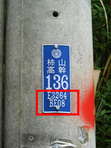
The string "E3264 BE08" on the image is the location of the pole in a coordinate system specific to the Taïwan power grid, which indicates the location of electric pole with a 10 meter precision.
The theory
We take our example "E3264 BE08", and read left to right. The most important information is letter E, which gives us a 50 km by 80 km rectangle.
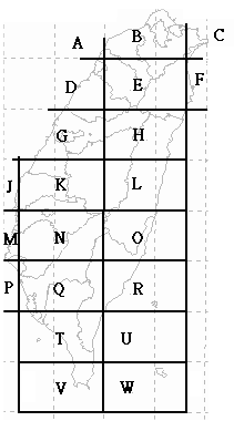
The second most important information is "3264", it tells us that within rectangle E, we are 32% eastward and 64% northward.
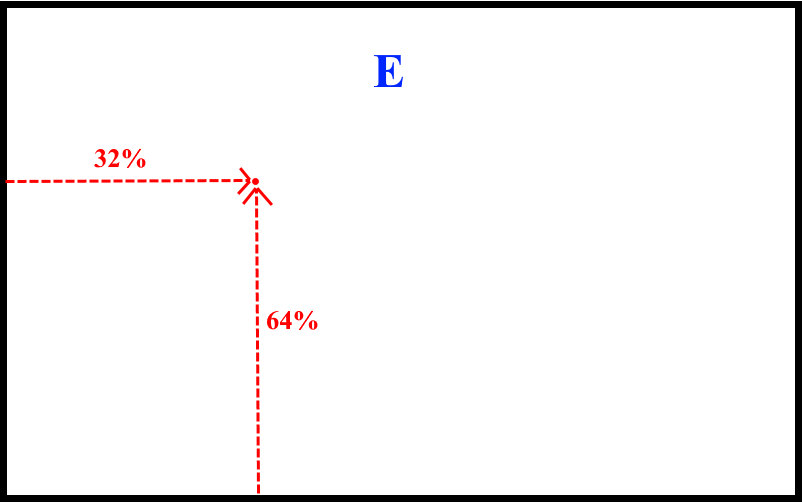
The string "BE08" is for precision but it is of no practical use ingame. If you want to know more about this coordinate system, this wiki page explains how to translate them in TWD67 coordinate system, which can then be converted in classic WGS84 coordinates.
Practical use
You can train with the Taïwan power grid coordinates geoguessr map and the Taïwan power grid quiz. Once you know the repartition of the letters, remembering 6 or 7 points is good enough to recreate the whole grid.

The easiest landmarks are :
- B slightly north of Hsinchu, C in Jiaoxi.
- F in Nanao township, on the west coast the border between Miaoli county and Hsinchu city is on the same horizontal.
- H is near Puli, where the google map indicates either Taïwan or Nantou county depending on the zoom.
- K is n the west coast at the border between Yunlin county and Chiayo county.
- N is just north of Tainan city, on the same horizontal you find Guanshan.
- R is in Taïmali.
Languages
Mainly chinese with some english.
- Chinese
- English (Latin)
Samples
Chinese
人人生而自由,在尊嚴和權利上一律平等。 他們被賦予了理性和良心,應該本著兄弟情誼的精神對彼此採取行動。
English
All human beings are born free and equal in dignity and rights. They are endowed with reason and conscience and should act towards one another in a spirit of brotherhood.