Welcome to the Great White North — a land of moose, maple, and massive landscapes from the mountains to the Maritimes.
Subdivisions
Canada is divided into ten provinces and three territories:
Provinces
- AB Alberta
- BC British Columbia
- MB Manitoba
- NB New Brunswick
- NL Newfoundland and Labrador
- NS Nova Scotia
- ON Ontario
- PE Prince Edward Island
- QC Québec
- SK Saskatchewan
Territories
- NT Northwest Territories
- NU Nunavut
- YT Yukon
License Plates
Like the United States, Canadian license plates differ in design and serial format from province to province and territory to territory. Only four provinces (British Columbia, Manitoba, Ontario, and New Brunswick) require both front and rear license plates; rhe remainder only require rear plates.
-
Alberta

-
British Columbia

-
Manitoba

-
New Brunswick

-
Newfoundland and Labrador

-
Nova Scotia

-
Ontario

-
Prince Edward Island

-
Québec

-
Saskatchewan

-
Northwest Territories

-
Nunavut

-
Yukon

Phone Codes
Canada is part of the North American Numbering Plan, which consists of all countries with the +1 country calling code. There is largely no pattern to the area codes. Area codes are three digits long, and the most populated regions have multiple area codes:
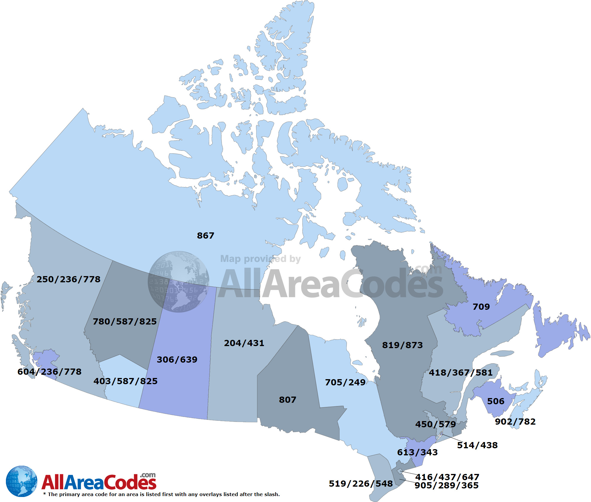
- Territories: 867
- British Columbia: 236/778
- Vancouver: 604
- All Other: 250
- Alberta: 587/825
- North: 780
- South: 403
- Saskatchewan: 306/639
- Manitoba: 204/431
- New Brunswick: 506
- Nova Scotia and P.E.I.: 902/782
- Newfoundland and Labrador: 709
- Ontario: (no province-wide code)
- Toronto: 416/437/647
- West: 807
- Central: 705/249
- South: 905/289/365
- Southwest: 519/226/548
- Southeast: 613/343
- Québec: (no province-wide code)
- Montréal: 514/438
- South: 450/579
- West: 819/873
- East: 418/367/581
The most common area code is listed first for each region, and the region-specific area codes are more common than province-wide area codes.
Roads, Signage, and Poles
Road Markings
Road markings in Canada are very similar to that of the United States, with yellow center lines and white shoulder lines. Center lines are usually double solid or single dashed—both common in the U.S. as well—but can occasionally be single solid, which is much rarer in the U.S.

The province of Alberta in particular also has white bollards with two black stripes at road intersections, which cannot be found in other provinces.
Signage
Signage on roads is mostly standardized, but can occasionally differ, especially in Ontario and Québec.
Stop Signs
The standard stop sign used in Canada is the same as that used in the United States, with the word "STOP" in white text on a red octagon:

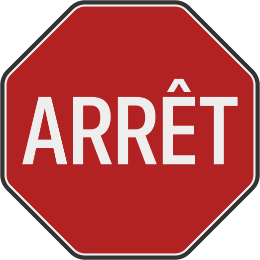
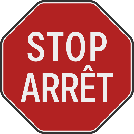
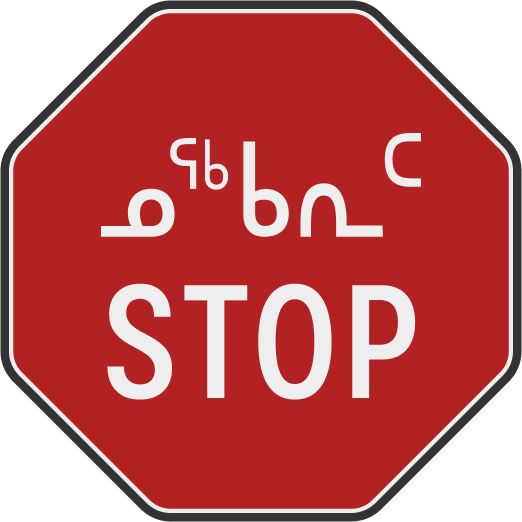
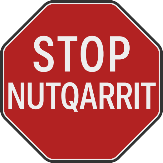
Other varieties in use are as follows:
-
French
Used in Québec
-
Bilingual English/French
Used in Ottawa ON and New Brunswick
-
Bilingual Inuktitut/English
Used in Iqaluit NU
-
Bilingual English/Inuinnaqtun
Used in Cambridge Bay / Iqaluktuuttiaq NU
Speed Limits
Notably, speed limit signage in Canada differs from that of the United States in that it uses the word "Maximum", as opposed to "Speed Limit" in the U.S., which can be helpful in distinguishing the two countries. In addition, speed limits in Canada are marked in kilometers per hour (km/h) which can help in distinguishing it as well, since the limits themselves are almost always in multiples of 10. While it is common to see a 40 mph or 40 km/h speed limit in the U.S. and Canada, respectively, highways in the U.S. typically have speed limits ending in 5 (for instance, 55 mph or 65 mph) while their Canadian counterparts are usually 90 km/h or 100 km/h.

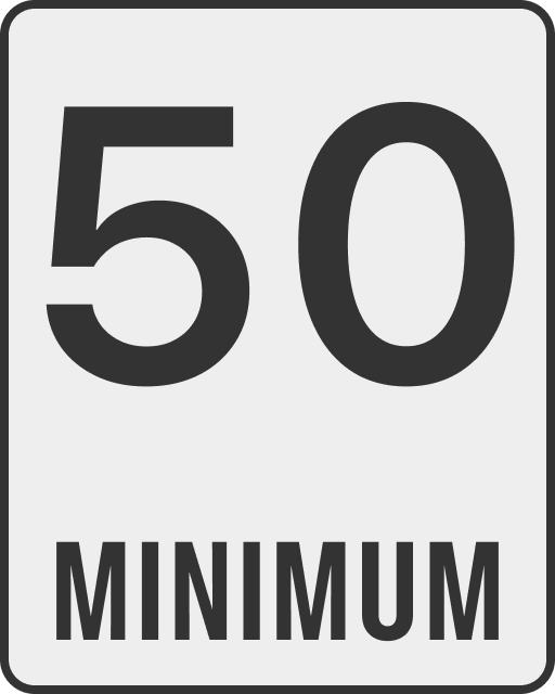
There are two main deviations from this design, shown below:
-
Ontario

-
Québec
Used only on autoroutes, under "Maximum" signs
Road Names
French road names typically come after the road type; as such, they are usually prefixed with Rue (road), Bd (boulevard), Av. (avenue), or Pl (place). Cardinal numbers in French are typically shortened with an e—so 42nd Avenue in Montréal would be signposted as 42e Avenue.
In Ottawa ON, New Brunswick, and P.E.I., street signs are usually bilingual, and so bear both the English and French names of the road on the same sign. So Orange Street, for instance, would be signposted as Rue Orange St., since Rue Orange and Orange St read as the French and English street names, respectively.
Highways & Road Numbering Schemes
The Canadian highway network is highly decentralized, with nearly all highways being managed by the provinces themselves. Most roads are signposted as provincial routes, and the Trans-Canada Highway is mostly built on top of existing provincial routes.
Trans-Canada Highway
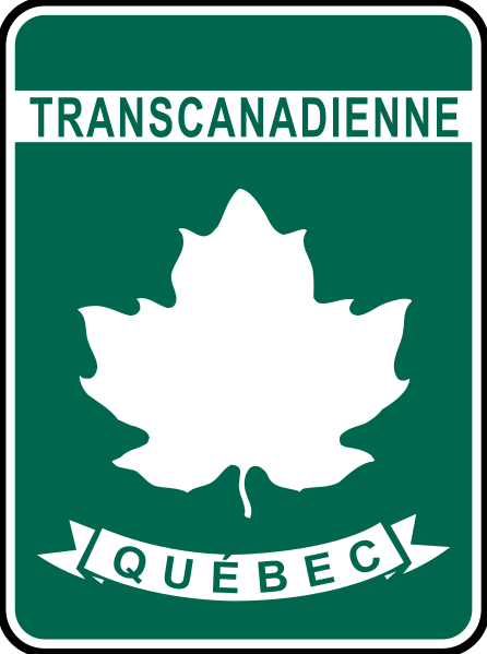
The Trans-Canada Highway system forms the only major, signed national highway network. It is typically signposted with a white maple leaf on a green sign and the province name in a ribbon at the bottom, with minor variations in two provinces:
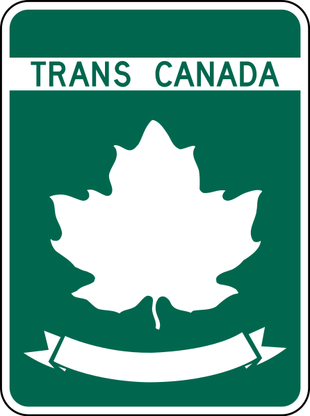
Other varieties of signage are shown below:
-
Québec
-
Newfoundland
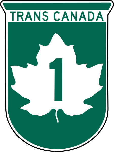
The main route runs west-east from Victoria BC to St. John's NL, mostly signed either as Highway 1 (western four provinces, P.E.I., and Newfoundland) or a numberless route (Ontario and Québec). New Brunswick signs the route as Highway 2, and Nova Scotia signs it as Highways 104-106. Asides from the main route, Highway 16 is another major highway on the network, running north of Highway 1 in the western four provinces. Other routes on the network are minor, mostly as alternate routes in Ontario and Québec, plus the Highway 100 ring road in Winnipeg MB.
Provincial Highways and Roads
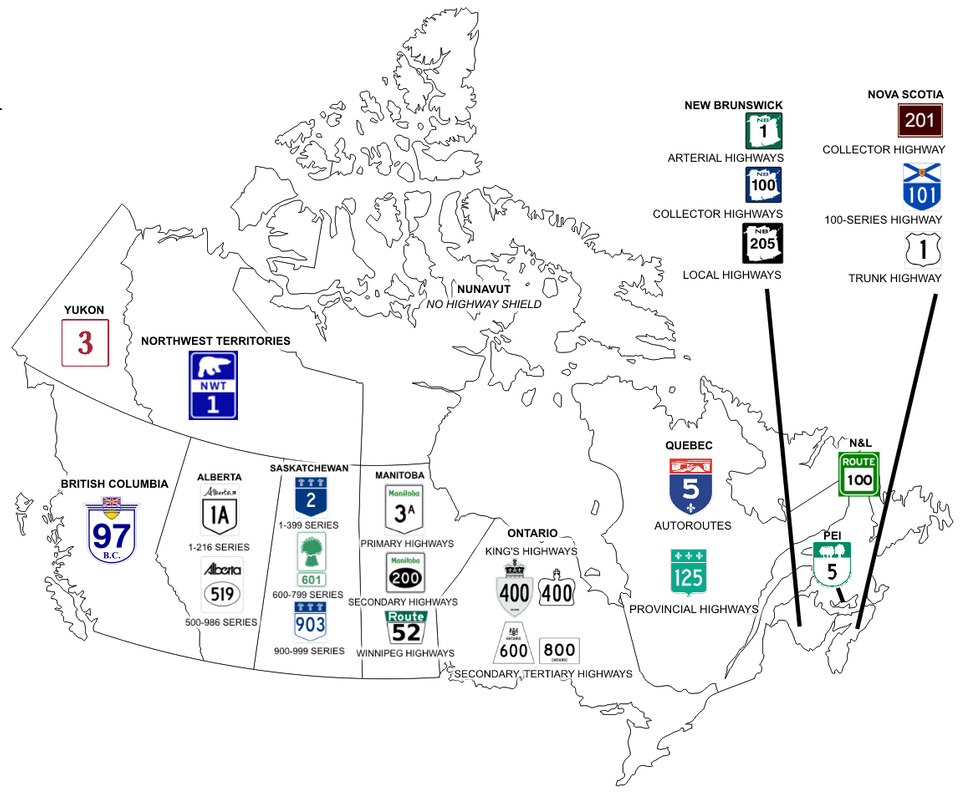
Every province and territory except Nunavut has a highway system, each with its own unique signage and network.
Alberta
Alberta's provincial highways are divided into two main types:
- Primary roads are the main intercity highways in the province, and are signposted on white signs with a squared bullet shield and the Alberta wordmark on top. These routes are numbered up to 100, plus two ring routes:
- Main series (1-100): major intercity routes
- 200-series: ring routes:
- Highway 201: Calgary ring road
- Highway 216: Edmonton ring road
- Route extensions and realignments use the 900- and X-series:
- 900-series: last two digits correspond to primary route
- X-series: number before the X corresponds to primary route
- Local roads are local and rural highways, and are signposted on white signs with an oval shield and the Alberta wordmark on top. These routes are numbered between 500 and 999, plus several X-series routes with numbers derived from primary roads:
- 500- and 600-series: run east-west, with numbering increasing to the north
- 500-series run south of Red Deer
- 600-series run north of Red Deer
- 700- and 800-series: run north-south, with numbering increasing to the east
- 700-series run west of Calgary and Edmonton
- 800-series run east of Calgary and Edmonton
- 500- and 600-series: run east-west, with numbering increasing to the north
Rural Roads
Like the other prairie provinces, Alberta has a grid numbering system for rural roads, denoted as range roads and township roads. They are numbered geographically based on distance from the U.S.-Canada and Saskatchewan borders. However, road names at intersections do not always carry the "range road" and "township road" designations, only the road number.
- Range roads run north-south, with numbering increasing to the west; numbering resets west of Calgary, which is on the 114th Meridian
- Township roads run east-west, with numbering increasing to the north
British Columbia
Highways in British Columbia are signposted with blue text on a blue-bordered round bullet shield, with the flag of British Columbia on top of the shield, and the province code B.C. printed below the route number. Routes are numbered between 1 and 118, with the suffix A being used in superscript to denote previous alignments of the primary route.
Manitoba
Manitoba's provincial highways are divided into two main types:
- Primary Trunk Highways (PTHs) are the main intercity highways in the province, and are signposted on white signs with a squared bullet shield and the Manitoba wordmark on top in green. These routes are numbered up to 100, plus two ring routes:
- Main series (1-99): Mainline intercity routes
- 100-series: Loop/spur routes:
- PTH 100/101: Winnipeg Beltway
- PTH 110: Bypass around Brandon
- PTH 190: West of Winnipeg
- Provincial Roads (PRs) are local and rural highways, and are signposted on white signs with an black oval shield and the Manitoba wordmark on top in green. These routes are numbered between 200 and 699:
Winnipeg City Routes
Winnipeg in particular has its own network of numbered routes, which are signposted on white trapezoidal signs with a green band on top bearing the word "Route" in white. They are numbered in the following pattern:
- Odd-numbered routes generally run east-west, with numbering increasing to the south.
- Even-numbered routes generally run north-south, with numbering increasing to the west.
Rural Roads
Like the other prairie provinces, Manitoba has a grid numbering system for rural roads, denoted as municipal roads. They are numbered geographically based on distance from the U.S.-Canada and Winnipeg. However, road names at intersections do not always carry the "municipal road" designation, only the road number and direction.
- North-South roads have numbering increasing away from Winnipeg, with E and W identifiers
- East-West roads have numbering increasing to the north
New Brunswick
New Brunswick's highways are divided into three series, and are signposted on colored square signs with the province's shape in the middle. They are numbered from 1 to 999:
- Arterial Highways are the primary highways of New Brunswick, and are marked by green signs. Most are numbered below 20, with Route 95 being the exception as an extension of the U.S. I-95.
- Collector Highways are the secondary highways of New Brunswick, and can be either connector routes or old alignments of primary highways. They are marked with blue signs, and are numbered from 100 to 199.
- Local Highways are the tertiary routes in New Brunswick, connecting smaller communities and areas to larger highways. They are marked with black signs, and are numbered from 200 onwards.
Newfoundland and Labrador
Highways in Newfoundland and Labrador are signposted on white signs with a green outline bearing the text "ROUTE", and are well-ordered with numbering based on the region:
Highways in Newfoundland and Labrador are signposted with black text on a white background, optionally with a green band featuring the word "ROUTE" on top. There are no tiers, but numbering is organized by region:
- Avalon Peninsula: 0- and 100-series routes
- Eastern Newfoundland: 200-series routes
- Western Avalon Peninsula: Routes 200-209
- Burin Peninsula: Routes 210-229
- Bonavista Peninsula: Routes 230-239
- Central Newfoundland: 300-series routes
- Kittiwake Coast, Fogo Island, and Twillingate: Routes 300-349
- Exploits River Valley & Bay d'Espoir: Routes 350-379
- Baie Verte: Routes 380-399
- Western Newfoundland: 400-series routes
- Great Northern Peninsula: Routes 420-439
- West Coast: Routes 400-409, 440-499
- Baie Verte: Routes 410-419
- Labrador: 500-series routes
Nova Scotia
Highways in Nova Scotia are divided into three main series, each signposted differently:
-
Arterial Highways are mostly expressways or freeways. They are signposted on a blue squared bullet with the provincial flag on top, and numbered between 100 and 199.
-
Trunk Highways are former arterial routes. They are signposted on a white U.S. highway shield, and numbered between 200 and 399.
-
Collector Highways are local routes across Nova Scotia, and are signposted with white text of a brown background. THey are numbered up to 33.
Ontario
Ontario's provincial highway network is divided into three main tiers:
- King's Highways are the largest intercity routes, and are signposted on a white bullet shield with a crown on top, or occasionally within a white crown. They are divided into three series:
- Main series (2-148): Intercity routes
- 400-series: Freeways and controlled-access routes
- Queen Elizabeth Way (QEW): Freeway between Buffalo USA and Toronto
- County Roads are local roads in southern Ontario, and are signposted on white inverted trapezoids, typically with the county name listed. They are numbered uniquely within each county, which means numbers can repeat across county lines.
- Secondary Highways are analogous to county roads but are limited to norther Ontario, where the county system is not in place. They are signposted in white upright trapezoids, and are numbered between 500 and 699.
Prince Edward Island
P.E.I.'s provincial highways are signposted in rounded bullet shields with green outlines and a stylized tree landscape on top, and are divided into three series:
- Arterial Highways are the major intercity routes in P.E.I., and are numbered up to 4, plus Route 1A.
- Collector Highways are secondary routes, and are numbered between 5 and 27.
- Local Highways are the smallest roads on the provincial road network, and are numbered between 100 and 399. They are organized by county:
- 100-series: Prince County
- 200-series: Queens County
- 300-series: Kings County
Québec
Provincial highways in Québec are mostly well-ordered, and follow the following numbering pattern:
- Odd-numbered routes generally run north-south or perpendicular to the Saint Lawrence River, with numbering increasing to the east.
- Even-numbered routes generally run east-west or parallel to the Saint Lawrence River, with numbering increasing to the north.
The provincial highways are also divided into two main types:
- Autoroutes: these are controlled-access freeways, and are signposted on blue shields with a red and white band on top and a fleur-de-lis on the bottom. Main routes have up to two digits, with deviation and collector routes adding a prefix to the main route number:
- Deviation/Bypass routes: even prefix
- Collector/Spur routes: odd prefix
- Provincial/Regional routes: these are all other highways in the province, and are signposted on a green French shield with three fleurs-de-lis on the top. All are numbered with three digits between 100 and 399 and are organized as follows:
- 100-series: Intercity routes
- 200-series: south of the Saint Lawrence River
- 300-series: north of the Saint Lawrence River
Saskatchewan
Saskatchewan's provincial highways are divided into three main types:
- Primary roads are the main intercity highways in the province, and are signposted on blue shields with three wheat symbols on top. Routes are numbered up to 199:
- Main series (1-99): major southern routes
- 100-series: major northern routes, usually connect to a southern road given by the last two digits
- Secondary roads are mainly spur and distributor routes branching off of primary routes. 200- and 300-series roads typically use the same shields as primary roads, while 900-series roads use a similar shield with a white background and blue text.
- 200- and 300-series: secondary southern routes, usually connect to the primary road given by the last two digits
- 900-series: secondary northern routes
- Minor roads are mostly gravel roads that form a grid across the province, and are signposted with green text on a green-bordered sign with a depiction of a wheat bundle in green on top. They are numbered between 600 and 799:
- 600-series: run north-south, with numbering increasing to the west.
- 700-series: run east-west, with numbering increasing to the north.
Rural Roads
Like the other prairie provinces, Saskatchewan has a grid numbering system for rural roads, and like Alberta uses the terms range road and township road. They are numbered geographically based on distance from the U.S.-Canada and Manitoba borders.
- Range roads run north-south, with numbering increasing to the west
- Township roads run east-west, with numbering increasing to the north
Territorial Highways
- Northwest Territories: There are ten territorial highways in the Northwest Territories, all signposted on a blue background with a polar bear and a white band with the code NWT.
- Yukon: There are fourteen territorial highways in Yukon, all signposted on signs of different colors, and with the number in a serif font.
- Nunavut: There are no numbered highways in Nunavut, and it is not connected by road to the rest of Canada.
Geography
The geography of Canada varies immensely from west to east. These are teh geographic macroregions of Canada, with the rough region:
-
Pacific Cordillera
British Columbia and western Alberta
This region is densely forested, and has Canada's tallest mountains. It looks similar to the United States' Pacific Northwest.
-
Prairies
Alberta, Saskatchewan, and Manitoba
This region is incredibly flat, with mostly straight roads and nearly no landform features. It also bears almost no forests or trees across the landscape.
-
Canadian Shield
Northern Ontario and Québec, Labrador, and far-northern Prairies
This region is fairly forested, and has thousands of lakes dotting the landscape.
-
Great Lakes and St. Lawrence
Southern Ontario and Québec
The most densely populated region of Canada, this region is similarly flat to the Prairies, but contains more forest and shrubbery, and overall possesses more greenery. Also contains Canada's wine region, and has lots of farming.
-
Maritimes
New Brunswick, Nova Scotia, P.E.I., and Newfoundland
Part of the Appalachians, this region contains some mountains, although none as big as those on the west coast. This area is densely forested as well, and looks similar to New England, especially in the southern reaches.
-
Northern Canada
Yukon, Northwest Territories, and Nunavut
These areas have a very variable geography, with some larger mountains in the west near the borders with British Columbia and Alaska, and cold, lake-ridden landscapes in the center and east. The northernmost reaches, including the Canadian Arctic, are the coldest parts of Canada, and are often covered with snow.
Architecture
Language
English and French are co-official languages in Canada at the federal level, with only one monolingual French province (Québec) and one officially bilingual province (New Brunswick). All other provinces use English as the primary language, whether official or de facto. The three territories, being federally governed, have English and French as co-official languages, but N.W.T., and Nunavut have a variety of indigenous languages that share official status.
Script
Both English and French use the 26 standard letters of the Latin alphabet:
Aa Bb Cc Dd Ee Ff Gg Hh Ii
Jj Kk Ll Mm Nn Oo Pp Qq Rr
Ss Tt Uu Vv Ww Xx Yy Zz
In addition, French employs several accents and diacritics, shown below:
Àà Ââ Ææ Çç Éé Èè Êê Ëë
Îî Ïï Ôô Œœ Ùù Ûû Üü Ÿÿ
Samples
English
All human beings are born free and equal in dignity and rights. They are endowed with reason and conscience and should act towards one another in a spirit of brotherhood.
French
Tous les êtres humains naissent libres et égaux en dignité et en droits. Ils sont doués de raison et de conscience et doivent agir les uns envers les autres dans un esprit de fraternité.
Meta-Gaming
Coverage
Most of southern Canada is covered, although many minor dirt and gravel roads in the Prairie provinces do not have coverage, especially those further north.
Yukon is the most widely covered of the territories, with most of the territory's highways having coverage; some portions of routes 4, 5, and 6 being the main holdouts.
The Northwest Territories has only two major routes covered: from the Alberta border to Yellowknife, and from the Yukon border near Fort McPherson to the Arctic Ocean at Tuktoyaktuk. The hamlet of Tulita is covered as well. There is some additional spillover coverage as well: near Tungsten on the Yukon border, and in the northern reaches of Wood Buffalo National Park AB.
Only two towns in Nunavut are covered: Cambridge Bay / Iqaluktuuttiaq and Iqaluit. Iqaluit is easily recognizable due to the snowy coverage, and both use bilingual stop signs.
Elsewhere in Canada, the town of Churchill MB is notable for being disconnected from the rest of the Canadian road network, and is easily recognizable thanks to the snowy coverage and distinctive street signs with polar bears on them. In Labrador, the towns of Labrador City and Happy Valley-Goose Bay are covered, as well as the QC-389/NL-500 corridor that connects it to the rest of Canada, and the western section of the NL-510.
Map Library
Countrywide Maps
- Official Map
- IntersectionGuessr by slashP
- Balanced by slashP
- AI-Generated by Goaff (YT) paschtetli
Regional Maps
Subdivision Maps
- British Columbia by Werdok
- Alberta by Werdok
- Saskatchewan by Werdok
- Manitoba by Werdok
- Ontario by Werdok
- Québec by Werdok
- New Brunswick by Werdok
- Nova Scotia by Werdok
- Prince Edward Island by Werdok
- Newfoundland and Labrador by Werdok
Thematic Maps
Most Similar
United States
Canada's neighbor to the south looks and feels very similar, largely because most of the Canadian population (and coverage) is very close to the U.S. border. Be on the lookout for the following:
- French: French is an official language in Canada, but is not in the U.S. Spanish is the de facto second language of the U.S.
- Road lines: While not a definitive tool, a single solid yellow line in the middle of the road is occasionally used in Canada, whereas it is incredibly rare in the U.S., where double-solid yellow center lines are standard.
- Signs in kilometers: While the U.S. uses the imperial system, Canada has standardized the use of the metric system—so distances will be in kilometers (km), while speed limits will be in kilometers per hour (km/h).